
चित्र:Le Gan Chenpo (Himalaya, Népal) (8446635289).jpg

यै पूर्व रुपको आकार: ७९९ × ५९९ पिक्सल। और रिजोल्युशनहरु: ३२० × २४० पिक्सल • ६४० × ४८० पिक्सल • १,०२४ × ७६८ पिक्सल • १,२८० × ९६० पिक्सल • १,३६५ × १,०२४ पिक्सल।
खास फाइल (१,३६५ × १,०२४ पिक्सेलहरु, फाइल आकार: १.२८ मेगाबाइट, MIME प्रकार: image/jpeg)
_(8446635289).jpg)
सारांश:
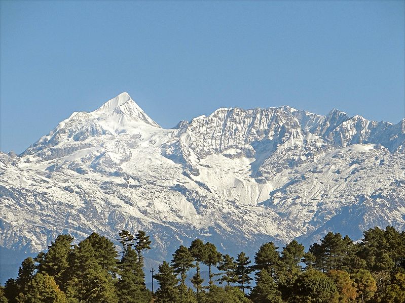
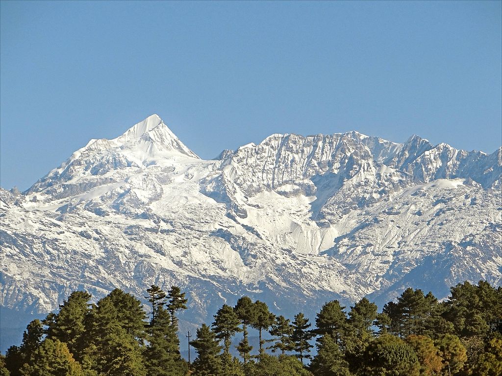
| बेलिविस्तार | South face of Gangchempo (Fluted Peak) 6387 m, as seen from Nagarkot at 1980 m. Nagarkot is a village in the Bhaktapur district of Nepal, about 32 kilometres (20 mi) east of Kathmandu and 14 kilometres (9 mi) northeast of Bhaktapur. Nagarkot is located at the top of the mountains to the east of the Kathmandu Valley. The view is of the "Langtang Himalayan Range". |
| मिति | Taken on २१ जनवरी २०१३, 09:03 |
| स्रोत | Le Gan Chenpo (Himalaya, Népal) |
| लेख्यामान्सु | Jean-Pierre Dalbéra from Paris, France |
| Camera location | | View this and other nearby images on: OpenStreetMap |
|---|
_(8446635289).jpg¶ms=027.717463_N_0085.520466_E_globe:Earth_type:camera_source:Flickr_&language=dty)
आज्ञापत्र दिन्नाछ़
This file is licensed under the Creative Commons Attribution 2.0 Generic license.
- तम खालि भया
- बाण – कार्यको प्रतिलिपि, वितरण र प्रेषितका लाइ
- मिस – कामको अनुशरण अद्दु
- तल दिया सर्तहरु अनुसार:
- एट्रिब्युसन – तमले निश्चित लेखक वा आधिकारिक व्यक्तिले निर्धारण गरया मान्यतामी आधारित होइबर ये कार्यलाई योगदान अद्दु सकंछौ( तर कोइलई सल्लाहकर्ताले आफ्नो इछ्या रे चाहना अनुसार अद्दु सक्दाईनन्)|
| This image, originally posted to Flickr, was reviewed on 15 February 2013 by the administrator or reviewer File Upload Bot (Magnus Manske), who confirmed that it was available on Flickr under the stated license on that date. |
| Annotations | This image is annotated: View the annotations at Commons |
फाइल इतिहास
तिथि/बेलामी क्लिक अरि तैबेला(समय) यो फाइल कसो थ्यो भणी हेद्द सकिन्याछ ।
| तिथि/बेला | थम्बनेल | आयाम | प्रयोगकर्ता | टिप्पणी | |
|---|---|---|---|---|---|
| यैलको | २१:०४, १५ फेब्रुअरी २०१३ | | १,३६५ × १,०२४ (१.२८ मेगाबाइट) | File Upload Bot (Magnus Manske) | Transferred from Flickr by User:russavia |
फाइल उपयोग
यै चित्रमी निम्नपाना जोडिनान:
विश्वव्यापी फाइल प्रयोग
निम्न और विकिहरुमि यै फाइलको प्रयोग:
- en.wikiquote.org मि उपयोग
- et.wikipedia.org मि उपयोग
- hi.wikipedia.org मि उपयोग
- it.wikivoyage.org मि उपयोग
- kbp.wikipedia.org मि उपयोग
- mai.wikipedia.org मि उपयोग
- ms.wikipedia.org मि उपयोग
- new.wikipedia.org मि उपयोग
_(8446635289).jpg)