
चित्र:Districts and tehsils of Pakistan.png

यै पूर्व रुपको आकार: ६३५ × ५९९ पिक्सल। और रिजोल्युशनहरु: २५४ × २४० पिक्सल • ५०९ × ४८० पिक्सल • ८१४ × ७६८ पिक्सल • १,०८५ × १,०२४ पिक्सल • १,४९६ × १,४१२ पिक्सल।
खास फाइल (१,४९६ × १,४१२ पिक्सेलहरु, फाइल आकार: ७६ किलोबाइट, MIME प्रकार: image/png)

|
File:Map of Pakistan (2017).svg is a vector version of this file. It should be used in place of this PNG file when not inferior.
File:Districts and tehsils of Pakistan.png → File:Map of Pakistan (2017).svg
For more information, see Help:SVG. |
.svg) |
|
|
File:Map of Pakistan (2018).svg is a vector version of this file. It should be used in place of this PNG file when not inferior.
File:Districts and tehsils of Pakistan.png → File:Map of Pakistan (2018).svg
For more information, see Help:SVG. |
.svg) |
सारांश:
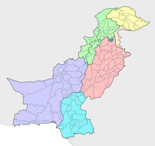
| बेलिविस्तार | Map of the districts of Pakistan, with their constituent tehsils (thin white borders). Map includes the disputed areas. Created by Rarelibra 20:47, 31 October 2007 (UTC) for public domain use, using MapInfo Professional v8.5 and various mapping resources. |
| मिति | ३१ अक्टोबर २००७ (original upload date) |
| स्रोत | मेरो आफ्नोई काम |
| लेख्यामान्सु | Rarelibra |
आज्ञापत्र दिन्नाछ़
| I, the copyright holder of this work, release this work into the public domain. This applies worldwide. In some countries this may not be legally possible; if so: I grant anyone the right to use this work for any purpose, without any conditions, unless such conditions are required by law. |
फाइल इतिहास
तिथि/बेलामी क्लिक अरि तैबेला(समय) यो फाइल कसो थ्यो भणी हेद्द सकिन्याछ ।
| तिथि/बेला | थम्बनेल | आयाम | प्रयोगकर्ता | टिप्पणी | |
|---|---|---|---|---|---|
| यैलको | ०३:०१, १० मे २०१९ | | १,४९६ × १,४१२ (७६ किलोबाइट) | Milenioscuro | recolored, cut out leftover areas |
| १६:२९, १३ जुन २०१८ |  | २,११२ × १,६३२ (११० किलोबाइट) | Balti sahib | Added the districts of Northern Pakistan (G-baltista), also included Fata into KPK province as per administeratives changes because of Fata Reforms; which merged Fata into KPK province. | |
| २१:५९, ८ अगस्ट २०१० |  | २,११२ × १,६३२ (१३८ किलोबाइट) | AnonyLog | Aksai Chin is not claimed by Pakistan; this is too complicated to have as currently represented. Also indicates to a newcomer to Pakistan that it administers all of J&K as one district!.. | |
| १८:४८, १३ नोभेम्बर २००९ |  | २,११२ × १,६३२ (१४२ किलोबाइट) | Nomi887 | Added Disputed Kashmir Regions and also added colours for more clarity. | |
| ०२:३२, १ नोभेम्बर २००७ |  | २,११२ × १,६३२ (७२ किलोबाइट) | Rarelibra | Map of the tehsils of Pakistan. Map includes the disputed areas. Created by ~~~~ for public domain use, using MapInfo Professional v8.5 and various mapping resources. |
फाइल उपयोग
यै चित्रमी निम्नपाना जोडिनान:
विश्वव्यापी फाइल प्रयोग
निम्न और विकिहरुमि यै फाइलको प्रयोग:
- ar.wikipedia.org मि उपयोग
- awa.wikipedia.org मि उपयोग
- ba.wikipedia.org मि उपयोग
- be-tarask.wikipedia.org मि उपयोग
- bg.wikipedia.org मि उपयोग
- bn.wikipedia.org मि उपयोग
- bxr.wikipedia.org मि उपयोग
- diq.wikipedia.org मि उपयोग
- en.wikipedia.org मि उपयोग
- fa.wikipedia.org मि उपयोग
- gl.wikipedia.org मि उपयोग
- hi.wikipedia.org मि उपयोग
- incubator.wikimedia.org मि उपयोग
- inh.wikipedia.org मि उपयोग
- it.wikipedia.org मि उपयोग
- ka.wikipedia.org मि उपयोग
- lez.wikipedia.org मि उपयोग
- mai.wikipedia.org मि उपयोग
- ms.wikipedia.org मि उपयोग
- new.wikipedia.org मि उपयोग
- nl.wikipedia.org मि उपयोग
- pa.wikipedia.org मि उपयोग
- pnb.wikipedia.org मि उपयोग
- ps.wikipedia.org मि उपयोग
- pt.wikipedia.org मि उपयोग
- ru.wikipedia.org मि उपयोग
- sd.wikipedia.org मि उपयोग
- simple.wikipedia.org मि उपयोग
- tg.wikipedia.org मि उपयोग
- tl.wikipedia.org मि उपयोग
- uk.wikipedia.org मि उपयोग
- ur.wikipedia.org मि उपयोग
येइ फाइलओ more global usage हेर: