
चित्र:Arctic.svg

Size of this PNG preview of this SVG file: ४७८ × ५९९ पिक्सल. और रिजोल्युशनहरु: १९१ × २४० पिक्सल • ३८३ × ४८० पिक्सल • ६१३ × ७६८ पिक्सल • ८१७ × १,०२४ पिक्सल • १,६३४ × २,०४८ पिक्सल • ५०५ × ६३३ पिक्सल।
खास फाइल (SVG चित्र,सानतिनो ५०५ × ६३३ पिक्सेलहरु, फाइल आकार: १.५ मेगाबाइट)
सारांश:
| बेलिविस्तार |
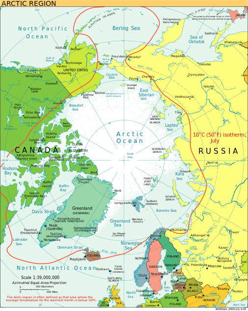
English: A view of the Arctic. The 10 °C (50 °F) mean isotherm in July line, displayed red, is commonly used to define the border of the Arctic region. |
| मिति | फेब्रुअरी २०१३ (original upload date) |
| स्रोत | CIA World Factbook |
| लेख्यामान्सु | CIA World Factbook |
| अन्य संस्करणहरू |
[]
|


.svg)


|
This SVG file contains embedded text that can be translated into your language, using any capable SVG editor, text editor or the SVG Translate tool. For more information see: About translating SVG files. |
आज्ञापत्र दिन्नाछ़
This image is in the public domain because it contains materials that originally came from the United States Central Intelligence Agency's World Factbook.
|
 |
फाइल इतिहास
तिथि/बेलामी क्लिक अरि तैबेला(समय) यो फाइल कसो थ्यो भणी हेद्द सकिन्याछ ।
| तिथि/बेला | थम्बनेल | आयाम | प्रयोगकर्ता | टिप्पणी | |
|---|---|---|---|---|---|
| यैलको | ०२:४५, १२ अगस्ट २०२३ | | ५०५ × ६३३ (१.५ मेगाबाइट) | Mahagaja | correct spelling of Kangiqliniq |
| ००:१४, १० अगस्ट २००९ |  | ५०५ × ६३३ (१.५ मेगाबाइट) | Ysangkok | compact code, no visible changes afaik | |
| ०५:१९, २० अगस्ट २००७ |  | ५०५ × ६३३ (१.६३ मेगाबाइट) | StephenHudson | Reverted to earlier revision | |
| ०४:०३, २० अगस्ट २००७ |  | १,०१० × १,२६७ (१.४ मेगाबाइट) | StephenHudson | Increased base pixel size to make text readable. | |
| २३:०२, २४ जनवरी २००६ |  | ५०५ × ६३३ (१.६३ मेगाबाइट) | Moyogo | stripped useless stuff | |
| ०२:१७, २४ जनवरी २००६ |  | ५०५ × ६३३ (१.९५ मेगाबाइट) | Sanao | Arctic<br /> Origin : CIA World Factbook Category:SVG maps Category:Arctic |
फाइल उपयोग
यै चित्रमी निम्नपाना जोडिनान:
विश्वव्यापी फाइल प्रयोग
निम्न और विकिहरुमि यै फाइलको प्रयोग:
- ace.wikipedia.org मि उपयोग
- ady.wikipedia.org मि उपयोग
- af.wikipedia.org मि उपयोग
- ar.wikipedia.org मि उपयोग
- arz.wikipedia.org मि उपयोग
- ast.wikipedia.org मि उपयोग
- as.wikipedia.org मि उपयोग
- ba.wikipedia.org मि उपयोग
- bg.wikipedia.org मि उपयोग
- bn.wikipedia.org मि उपयोग
- ca.wikipedia.org मि उपयोग
- cy.wikipedia.org मि उपयोग
- da.wikipedia.org मि उपयोग
- da.wiktionary.org मि उपयोग
- de.wikipedia.org मि उपयोग
- el.wikipedia.org मि उपयोग
- en.wikipedia.org मि उपयोग
- Geography of Denmark
- Jan Mayen
- Svalbard
- Northern Canada
- History of Svalbard
- Contour line
- List of rivers of the Americas by coastline
- Arctic Bridge
- History of the petroleum industry in Canada (frontier exploration and development)
- Portal:Maps/Maps/Nautical
- Portal:Maps/Maps/Nautical/2
- Arctic Ocean
- Wikipedia:Graphics Lab/Map workshop/Archive/Aug 2009
- Sir James Lamont, 1st Baronet
- Arctic exploration
- en.wikibooks.org मि उपयोग
- eo.wikipedia.org मि उपयोग
- eo.wiktionary.org मि उपयोग
- es.wikipedia.org मि उपयोग
- es.wikibooks.org मि उपयोग
येइ फाइलओ more global usage हेर: